Home | About | Contacts | Latest News | Coming Events
It seems ironic that the closer you get to the Library, the less safe it is to get there. This is quite true of the current layout, and the approved plans have taken a simple, sensible approach for rerouting traffic which significantly improves the safety for people driving, walking, and riding to and from the Library. Unfortunately, the recently proposed changes create a new, far worse, traffic nightmare.
For more details, see the relevant sections below.
Although pedestrian access to the Library is currently quite good -- as it should be, since the original patrons didn't have cars -- many residents who try to go there find themselves forced to park unsafely on the street.

There is some parking in the back of the building, but exiting (#1 above) via the driveway onto Main Street is treacherous, since visibility looking north on Main Street is nowhere near sufficient.
For over five years the approved plans have addressed the existing safety problems by reconfiguring the driveway and parking to form three intersections instead of just one.
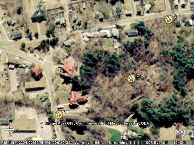
In these plans, the historic driveway entrance off Main Street (#1 above) remains intact, but it will be only one-way in. Visibility from both directions to get in hasn't ever been a problem. By adding copious parking behind the expanded Library (#2 above), there's no longer any reason for anyone to continue with the hazardous practice of on-street parking. Note that since the driveway continues through the parking lot, there aren't any hazardous off-street intersections in this plan.
Perhaps the most important feature of the approved plans is the new entrance and exit off Lincoln Street opposite Day Street (#3 above). Not only does this connect nicely with the Sheridan/Day corridor to the schools complex, but it also forms a traditional perpendicular intersection with sufficient visibility in all directions.
All Library traffic under this plan would exit via Lincoln Street. Anyone living north of the Library would be able to take an easy right into the Main Street entrance. Everyone else could choose either entrance as they see fit.
All in all, it's a simple, straightforward, sensible, and eminently safe plan.
So what, then, are we to make of the recently proposed changes which reroute the Library access road? Now instead of entering and exiting off Lincoln Street, all of that traffic -- estimated by the Library's engineers at over 700 round trips daily -- will go where?
Let's take a look:
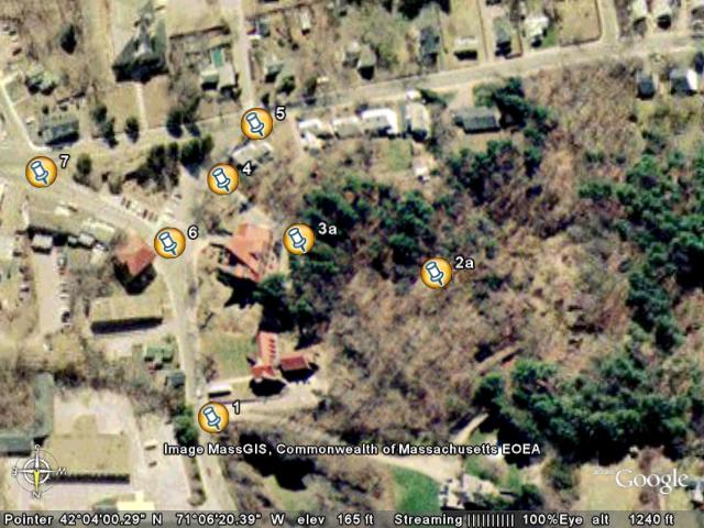
As with the approved plan, there's a one-way entrance off Main (#1 above), leading to a parking area out back. In this case, the size of the parking area is significantly reduced, and the intersection between the main parking lot and the access road (#2a above) is now a T-shape.
From there, the proposed plan has the access road cutting up through the back of the hill behind Ames Memorial Hall -- an excavation which is as much as a dozen feet below grade next to a drainage ditch -- over the top of the hill, and back down the Hall's driveway on the other side of the hill. Right at the crest of the hill is a four-way intersection (#3a above) where:
Anyone visiting the Library who can't find parking down behind the hill could also park up in the Hall's lot, although it's unclear how they'll be able to safely walk down to the Library from there. The converse holds for participants at Hall events who use the Library's lot downhill for overflow parking. For evening events, that'd mean people walking downhill to find their cars, then driving back up to exit. The current proposal doesn't seem to do much in the line of sidewalks, lighting, etc. to address this use case.
The remaining four intersections that are directly impacted by this plan all surround the Rockery:
To understand the true impact of this plan on traffic safety around the Rockery, it's helpful to divide the various maneuvers required into two categories -- easy turns and hard turns. Currently, most traffic around the Rockery is through traffic, and those drivers get to make the "easy turns". The few people who have to make the "hard turns" either do so rarely and gingerly because they're attending an event at the Hall, or else they're one of the small set of people who live or work around the Rockery -- and anyone who does has been forced to learn the hard way just how poor the visibility gets when you try to turn the "hard way" at each of these four intersections.The proposed plan will now require 700 drivers a day to learn how to make those "hard turns" safely.
Once you get out of the driveway, how hard a time you have will depend on where you want to go next.
However, the learned behavior here is to pull up well past the stop line on the road, effectively into the path of westbound traffic on Lincoln, just so you can see far enough down that acute angle to judge the speed of cars accelerating up the hill.
Pedestrians attempting to do the same thing before crossing Lincoln heading South have it much tougher, since the curve of the road keeps you from seeing eastbound traffic before they've already arrived. In practice, most folks choose to either sprint and take their chances, or else stand out as far as they can and wait for a friendly oncoming driver to stop and let them cross.
All other traffic leaving the library needs to go through the Barrows/Main intersection by the flagpole (#6 above). In minimal traffic, with nobody parked in front of the Rockery, this works out better than you might expect, given all the acute angles and obscured views. However, once you add a few parked cars, the turns get much trickier if you want to turn any of the following directions:
Finally, for the sake of completeness, we should also mention this intersection (#7 above). Because it's a three-way stop with an acute angle, and one direction doesn't stop, drivers in each direction need to take asymmetric strategies to turn safely, depending on which way they're headed. We'll spare you the gory details, since most drivers in Town already know what they're dealing with here.